Heat reveals what color imagery cannot: a failing panel, a loose connector, an overloaded transformer, an underperforming string. Our differentiator is in-house ASNT Level III thermography paired with the Titan 1280 LWIR sensor, so the temperature in every pixel is a real, measurable value rather than a false-color picture.
Where Thermal Earns Its Place
Solar Fault Detection
Faults down to the individual panel and string, with hot-spot and underperformance mapping across large arrays.
Energy and Industrial
Heat and equipment monitoring across facilities, plus leak and anomaly detection where temperature reveals the problem.
Infrastructure and Buildings
Connector and conductor faults across T&D assets, and heat-loss surveys for buildings and infrastructure.
Proven on Solar at Scale
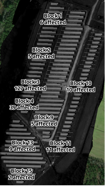
At the Merced 105 MW site we identified 227 faults across 12,102 panels, accounting for roughly 10.2 million kWh of affected production. At Baldy Mesa, a 250 MW site, thermal and imagery surfaced more than 3 million dollars in losses. Thermal finds the problems a clipboard walk never will.
What We Detect
Solar: panel and string faults, hot spots, and underperformance.
T&D: hot connectors, splices, and overloaded conductors and transformers.
Facilities: equipment heat and developing faults across energy and industrial sites.
Leaks and anomalies: where temperature reveals what imagery hides.
Buildings: heat-loss and envelope surveys.
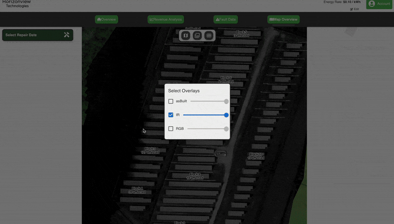
Captured together: thermal flown with RGB and NIR for aligned context.
From Sky to Insight™
Because thermal flies on the same aircraft as our RGB and NIR imagery, you get heat and visual context from a single mission, delivered through the Insight™ platform and ready to act on.