
From portfolio-level digital twins to module-level diagnostics, Horizonview makes aerial data simple, precise, and actionable.
Aircraft or drone collects aerial IR + RGB data.
Data processed through Horizonview's analytics engine.
Insights delivered into Insight™ platform.
Field teams receive clear, work-order-ready outputs.
From planning to operations, Horizonview Insight™ provides the intelligence behind every decision.
Each dataset is automatically classified by defect type and severity—giving engineers, EPCs, and O&M teams one consistent source of truth.
Every inspection is analyzed using AI and expert validation to ensure accuracy across thousands of images and sites.
Our reports and platform views highlight what matters most—so stakeholders can act fast without sorting through noise.
Compare inspection results over time, monitor trends, and verify the impact of corrective actions across your portfolio.
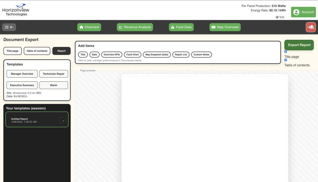
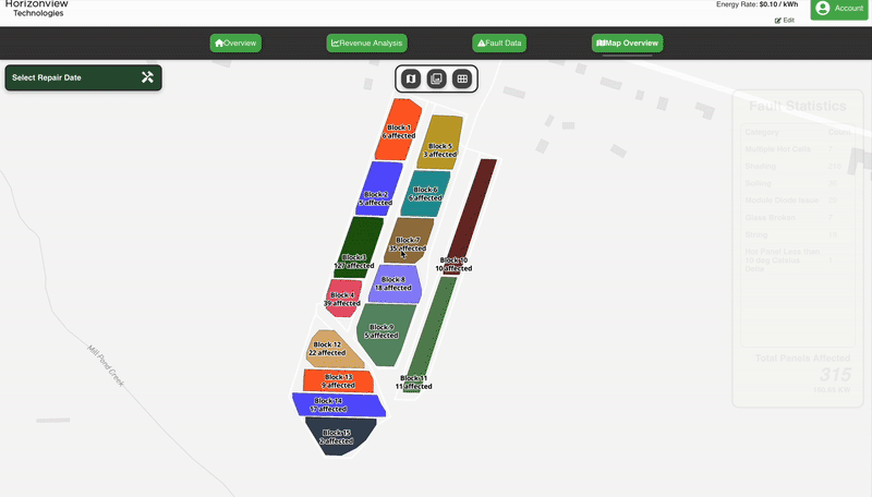
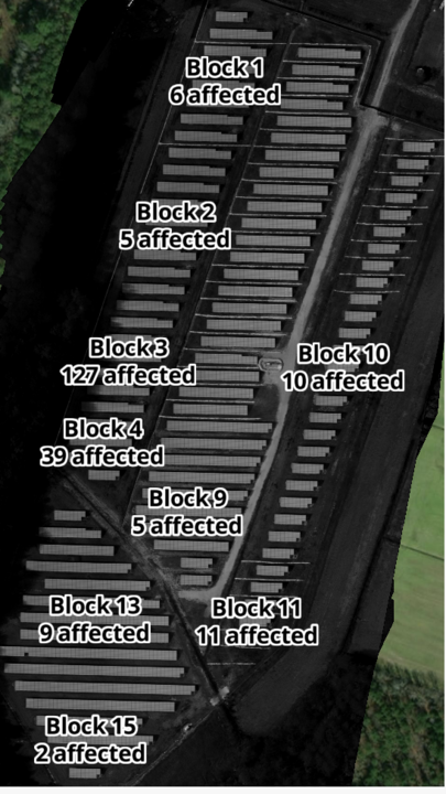
A living, data-rich map of your solar assets. Horizonview Insight™ reconstructs every solar site into a geolocated digital twin, integrating aerial imagery, inspection data, and component-level information into one intuitive map-based interface. Analyze data, trigger tasks, and manage remediation workflows directly from your browser. Each site becomes a single system of record—clean, auditable, and accessible anytime.
The result: a fully digital representation of your portfolio—always current, always actionable.

A complete visual analytics suite for utility-scale solar.
Horizonview goes beyond detecting hot spots. Our combined IR + RGB datasets reveal performance, environmental, and structural insights across your sites—so you can reduce risk, boost yield, and extend asset life.
Identify and classify faults before they escalate into production loss.
Detect debris buildup, tracker alignment issues, or storm damage that could impact compliance or safety.
Use data trends to benchmark sites and contractors, ensuring best practices are followed across all projects.
Flexible aerial data collection for any scale of operation.
Horizonview operates a fleet of manned aircraft designed for high-efficiency, high-resolution solar inspection. Our systems can scan hundreds of megawatts per flight hour—providing uniform, calibrated data across entire portfolios.
When projects require drone support, we deploy or process your drone data through the same analytics pipeline. This ensures consistency in every deliverable, whether captured from 300 feet or 3,000.
By combining flight flexibility with a unified analytics platform, Horizonview delivers reliable data for every site, every time.


Data your technicians can actually use.
Insight™ is designed for field accessibility. Technicians can access inspection results, navigate directly to fault coordinates, and upload notes or images—even from the field.
Horizonview’s orthomosaic-based analytics set a new standard for reliability and scalability.
Unlike most inspection platforms that analyze imagery frame-by-frame, Horizonview reconstructs every site into a fully georeferenced orthomosaic — a true, measurable digital twin of your asset.
This method provides unmatched spatial precision and eliminates the guesswork common in stitched or sequential frame data.
The result: **99.8% analytical accuracy** across every inspection — no guessing which panel a fault belongs to, no misaligned coordinates, and no uncertainty in the data you rely on.
Why Orthomosaics Matter

Connect Horizonview Insight™ with the tools your teams already use.
Your inspection data shouldn’t live in a silo. Horizonview Insight™ includes open, bidirectional APIs that let you share georeferenced images, AI-classified faults, and digital twin models with your existing enterprise systems.
Push repair tickets directly into ServiceNow or Salesforce, sync asset health metrics with IBM Maximo, or visualize inspection data through your BI tools — all automatically.
Our APIs streamline workflows, reduce manual data entry, and ensure that every insight captured in Horizonview flows seamlessly into your organization’s operational ecosystem.
Integrate inspection data directly into CMMS, ERP, and analytics systems.
Generate service tickets and maintenance actions instantly from inspection results.
Built to connect with leading platforms like SAP, IBM Maximo, ServiceNow, and Power BI.
Whether you manage a single site or a global portfolio, integrations scale effortlessly.
Horizonview Insight™ connects data, people, and platforms — building one unified digital workflow from capture to action.